DJI Enterprise
DJI Enterprise Products
Authorized DJI Enterprise Dealer
DJI Matrice 300 RTK
The Most Powerful Quad Copter
The Matrice 300 RTK is DJI’s latest commercial drone platform that takes inspiration from modern aviation systems. Offering up to 55 minutes of flight time, advanced AI capabilities, 6 Directional Sensing & Positioning and more, the M300 RTK sets a whole new standard by combining intelligence with high-performance and unrivaled reliability.
- 15 Km Improved Transmission Range System
- 55 min. Enhanced Flight Performance
- Multiple Payload Configurations
- Smart Inspection
- Live Mission Recording
- AI Spot-Check
- Advanced Dual Control

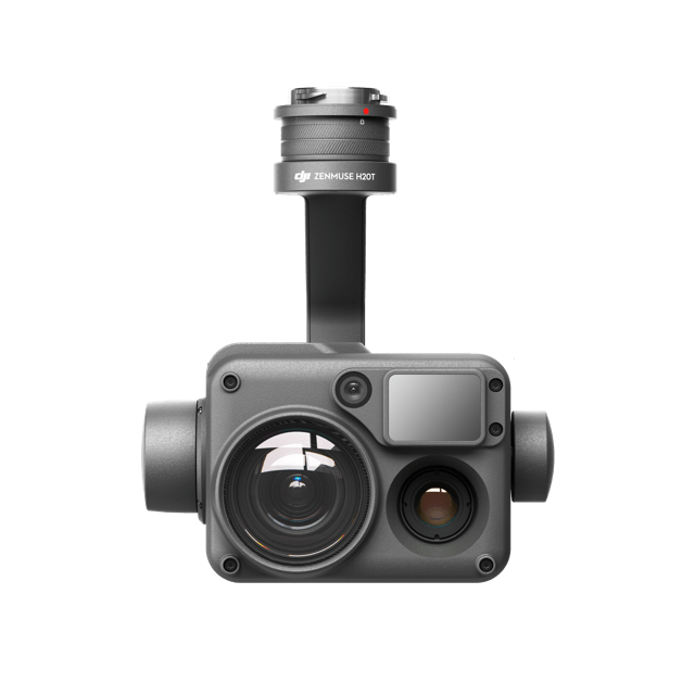
DJI H20 Series
All The Sensors You Need – In One
Capture everything. Up close or from a distance. In true living color or thermal. An integrated laser rangefinder (LRF) measures the distance to an object at up to 1200 m away. A powerful, integrated payload that unleashes advanced intelligent capabilities for DJI’s industrial drone platforms.
- Powerful RGB Zoom Camera
- Wide Camera
- Radiometric Thermal Camera
- Laser Rangefinder
DJI P1
The New Benchmark for Aerial Surveying
The Zenmuse P1 integrates a full-frame sensor with interchangeable fixed-focus lenses on a 3-axis stabilized gimbal. Designed for photogrammetry flight missions, it takes efficiency and accuracy to a whole new level.
- 45MP Full-frame Camera
- Multiple Fixed Focus Lens Options
- Smart Oblique Capture

DJI L1
A Lidar + RGB Solution for Aerial Surveying
The Zenmuse L1 integrates a Livox Lidar module, a high-accuracy IMU, and a camera with a 1-inch CMOS on a 3-axis stabilized gimbal. When used with Matrice 300 RTK and DJI Terra, the L1 forms a complete solution that gives you real-time 3D data throughout the day, efficiently capturing the details of complex structures and delivering highly accurate reconstructed models.
- Livox Lidar Module
- 20MP RGB Camera
- High-accuracy IMU
- Point Cloud LiveView

Phantom 4RTK
Built for Surveyors
Offering a range of control schemes and complimentary technologies, the DJI Phantom 4RTK is developed to provide survey-grade results with greater efficiency than ever before.
DJI has rethought its drone technology from the ground-up, revolutionizing its systems to achieve a new standard for drone accuracy – offering Phantom 4 RTK customers centimeter-accurate data while requiring fewer ground control points.
- 20MP RGB Camera
- Cover 250,000 square meters in 20min. with 2.74cm GSD and 5cm vertical accuracy

Mavic 2 Enterprise Advanced
Zoom in to Stay Safe
Capture clear images and videos from a safe distance. The M2EA’s high-resolution visual camera supports ultra zoom, so no detail is missed.
Make informed decisions by quickly identifying objects onsite using the M2EA’s integrated high-resolution thermal sensor, which supports Spot Meter and Area Measurement.
- 48MP RGB Camera
- High-resolution Radiometric Thermal Camera
- 10KM Control Range with 30min. flight time
